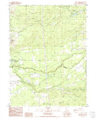
1985 Map of Shingletown
USGS Topo · Published 1986About this map
The settlement of Shingletown and the surrounding timber and water resources of northern California are mapped here as they appeared in the mid-1980s. The landscape is defined by its hydroelectric and agricultural water management systems, notably the complex of facilities along the forks of Battle Creek. Water infrastructure is dense throughout the region, including the Inskip Powerhouse, Inskip Dam, and South Powerhouse, which utilize the area's natural descent. The Darrah Springs State Fish Hatchery stands as a significant landmark in the western portion of the quadrangle. Geological features such as Black Butte and Jackass Butte provide topographic anchors for the region, while man-made additions like the Landing Strip and various pipelines reflect the mid-century development of this upland area near the Shasta Co Tehama Co line.
Find a feature on this map
40 named features on this map. Tap any name to fly to it.
Don’t see what you’re looking for? This feature index may not catch every label — zoom into the map to look around manually.
Map Details
Editions of this 1985 Shingletown Map
This is the sole edition of this map. No revisions or reprints were ever made.
Other maps of this area

1886 · Lassen Peak
USGS Topo · 1:250,000

1890 · Red Bluff
USGS Topo · 1:250,000

1892 · Lassen Peak
USGS Topo · 1:250,000

1894 · Lassen Peak
USGS Topo · 1:250,000

1894 · Red Bluff
USGS Topo · 1:250,000

1901 · Redding
USGS Topo · 1:125,000

1935 · Burney
USGS Topo · 1:96,000

1935 · Paynes Creek
USGS Topo · 1:96,000

1939 · Burney
USGS Topo · 1:125,000

1941 · Mineral
USGS Topo · 1:125,000