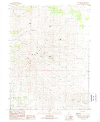
1989 Map of Shinn Mountain
USGS Topo · Published 1989About this map
Juniper Jim Spring and Toms Cabin Spring anchor a high-altitude landscape dominated by the prominent peaks of Shinn Mountain and Rush Creek Mountain. This 1980s terrain in Lassen County reveals a complex network of water sources and seasonal drainages, where life is defined by the availability of remote springs such as Bills Cabin Spring and Nye Spring. The land is carved by deep geographic features like Patch Rye Canyon, while the presence of Summit Troughs suggests a history of livestock management or travel through these mountain passes. Drainage systems including Rush Creek and Cherry Creek flow through the high country, connecting isolated points like McKissick Spring and Hall Springs to the wider valley floor. The map serves as a record of high-desert water infrastructure in the years before the modern era, showing the placement of remote cabins and spring-fed catchments.
Find a feature on this map
16 named features on this map. Tap any name to fly to it.
Don’t see what you’re looking for? This feature index may not catch every label — zoom into the map to look around manually.
Map Details
Editions of this 1989 Shinn Mountain Map
This is the sole edition of this map. No revisions or reprints were ever made.
Other maps of this area

1886 · Honey Lake
USGS Topo · 1:250,000

1891 · Honey Lake
USGS Topo · 1:250,000

1893 · Honey Lake
USGS Topo · 1:250,000

1954 · Observation Peak
USGS Topo · 1:62,500

1954 · Karlo
USGS Topo · 1:62,500

1954 · Ravendale
USGS Topo · 1:62,500

1954 · Shinn Mountain
USGS Topo · 1:62,500

1955 · Westwood
USGS Topo · 1:250,000

1958 · Westwood
USGS Topo · 1:250,000

1959 · Westwood
USGS Topo · 1:250,000