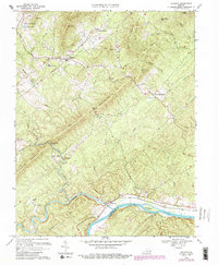
1969 Map of Shipman
USGS Topo · Published 1987About this map
Shipman sits along the Southern railroad line, serving as a focal point for this section of Nelson County as it appeared in the late 1960s. The landscape is defined by the convergence of the Tye River and the James River at the southern boundary, where the community of Norwood overlooks the riverbanks near Cunninghams Island. This area reflects a deep-rooted rural settlement pattern, where small communities like Variety Mills and Edge Hill are connected by winding valley roads between the prominent ridges of Findlay Mountain and Turner Mountain.
Find a feature on this map
57 named features on this map. Tap any name to fly to it.
Don’t see what you’re looking for? This feature index may not catch every label — zoom into the map to look around manually.
Map Details
Editions of this 1969 Shipman Map
4 editions found
Other maps of this area

1892 · Buckingham
USGS Topo · 1:125,000

1929 · Covesville
USGS Topo · 1:62,500

1935 · Covesville
USGS Topo · 1:62,500

1943 · Lovingston
USGS Topo · 1:62,500

1945 · Covesville
USGS Topo · 1:62,500

1946 · Lovingston
USGS Topo · 1:62,500

1947 · Roanoke
USGS Topo · 1:250,000

1959 · Roanoke
USGS Topo · 1:250,000

1961 · Shipman
USGS Topo · 1:62,500

1961 · Buckingham
USGS Topo · 1:62,500