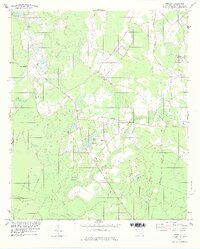
1978 Map of Shirley
USGS Topo · Published 1978About this map
Augusta Road and Orangeburg Road anchor the rural landscape of Hampton County, where small settlements like Shirley and Scotia sit amidst a network of low-lying wetlands. The geography is defined by the expansive Boggy Swamp and numerous waterways such as Pike Cr, King Branch, and Millpond Branch. For family historians, the area is notably dense with localized burial sites and country congregations, including Lawtonville Cem, Solomons Cem, and the Heavenly Rest Ch. The intersection of nature and infrastructure is evident near McKenzie Pond, where a local landing strip and Davis Cem reside near the water's edge. Further north, the town of Estill shows mid-century modernization with the Estill Municipal Airport and a secondary landing strip, contrasting the traditional rural character of nearby Sandhill Ch and Hopewell Ch.
Find a feature on this map
33 named features on this map. Tap any name to fly to it.
Don’t see what you’re looking for? This feature index may not catch every label — zoom into the map to look around manually.
Map Details
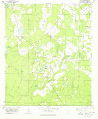
Editions of this 1978 Shirley Map
2 editions found
Other maps of this area

1918 · Varnville
USGS Topo · 1:62,500

1919 · Pineland
USGS Topo · 1:62,500

1919 · Shirley
USGS Topo · 1:62,500

1920 · Peeples
USGS Topo · 1:62,500

1943 · Pineland
USGS Topo · 1:62,500

1943 · Peeples
USGS Topo · 1:62,500

1943 · Shirley
USGS Topo · 1:62,500

1944 · Varnville
USGS Topo · 1:62,500

1947 · Savannah
USGS Topo · 1:250,000

1948 · Savannah
USGS Topo · 1:250,000