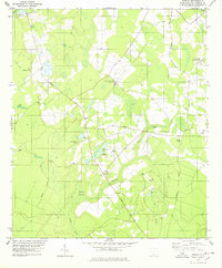
1978 Map of Shirley
USGS Topo · Published 1978About this map
St Marks Ch and the small settlement of Shirley anchor this landscape in western Hampton County, where the low country terrain is defined by an intricate network of wetlands and minor watercourses. The slow-moving waters of Boggy Swamp and Millpond Branch dominate the southern half of the map, carving paths through the dense vegetation. Long-established transportation corridors like Augusta Road and Orangeburg Road intersect the area, providing a sense of the historical connectivity between rural homesteads and nearby centers like Estill and Scotia.
Find a feature on this map
33 named features on this map. Tap any name to fly to it.
Don’t see what you’re looking for? This feature index may not catch every label — zoom into the map to look around manually.
Map Details
Editions of this 1978 Shirley Map
2 editions found
Other maps of this area

1918 · Varnville
USGS Topo · 1:62,500

1919 · Pineland
USGS Topo · 1:62,500

1919 · Shirley
USGS Topo · 1:62,500

1920 · Peeples
USGS Topo · 1:62,500

1943 · Pineland
USGS Topo · 1:62,500

1943 · Peeples
USGS Topo · 1:62,500

1943 · Shirley
USGS Topo · 1:62,500

1944 · Varnville
USGS Topo · 1:62,500

1947 · Savannah
USGS Topo · 1:250,000

1948 · Savannah
USGS Topo · 1:250,000