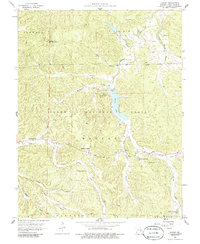
1958 Map of Shirley
USGS Topo · Published 1986About this map
Sunnen Lake and its prominent spillway serve as a central geographic anchor in this 1958 survey of the Missouri Ozarks. The landscape is defined by the headwaters of the Fourche Renault and its numerous tributaries, including Ashley Branch and Knox Branch. This area of the Clark National Forest is characterized by a high density of rural religious and educational sites, reflecting the dispersed nature of mid-century settlement.
Find a feature on this map
45 named features on this map. Tap any name to fly to it.
Don’t see what you’re looking for? This feature index may not catch every label — zoom into the map to look around manually.
Map Details
Editions of this 1958 Shirley Map
3 editions found
Other maps of this area

1901 · De Soto
USGS Topo · 1:125,000

1903 · Sullivan
USGS Topo · 1:125,000

1906 · Potosi
USGS Topo · 1:62,500

1943 · Berryman
USGS Topo · 1:62,500

1945 · Berryman
USGS Topo · 1:62,500

1946 · Richwoods
USGS Topo · 1:62,500

1947 · Sullivan
USGS Topo · 1:62,500

1948 · Richwoods
USGS Topo · 1:62,500

1949 · Saint Louis
USGS Topo · 1:250,000

1949 · Sullivan
USGS Topo · 1:62,500