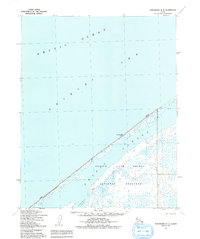
1950 Map of Shishmaref A-4
USGS Topo · Published 1992About this map
Bering Land Bridge National Preserve dominates this coastal survey, where the terrestrial world meets the Arctic Ocean and the Chukchi Sea. The geography is defined by a narrow barrier of land that separates the open sea from the tidal expanse of Shishmaref Lagoon. This environment, mapped from aerial photography taken in 1949 and 1950, reveals a landscape of complex hydrology where Trout Creek and Kugrupaga Inlet feed into the lagoon system. Human presence in this isolated reach of the Seward Peninsula is marked primarily by survival and transport, evidenced by the Sinrazat Shelter Cabin and the AMNWR Winter Trail (Approximate). These features underscore the region's reliance on seasonal routes and temporary shelters in an era before modern infrastructure reached these northern shores.
Find a feature on this map
8 named features on this map. Tap any name to fly to it.
Don’t see what you’re looking for? This feature index may not catch every label — zoom into the map to look around manually.
Map Details
Editions of this 1950 Shishmaref A-4 Map
2 editions found
Other maps of this area

1950 · Teller
USGS Topo · 1:250,000

1950 · Shishmaref
USGS Topo · 1:250,000

1950 · Teller D-3
USGS Topo · 1:63,360

1950 · Teller D-5
USGS Topo · 1:63,360
1950 · Shishmaref A-4
USGS Topo · 1:63,360

1950 · Shishmaref A-3
USGS Topo · 1:63,360
1950 · Teller D-4
USGS Topo · 1:63,360
1950 · Shishmaref B-3
USGS Topo · 1:63,360

1951 · Shishmaref
USGS Topo · 1:250,000

1951 · Teller
USGS Topo · 1:250,000