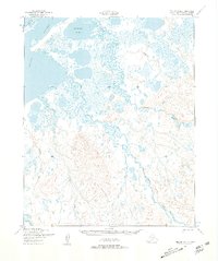
1950 Map of Teller D-4
USGS Topo · Published 1957About this map
The Arctic Lagoon and the complex tidal waters of the Kugrupaga Inlet dominate this coastal landscape of the Seward Peninsula. Mapped from aerial photography taken in 1949 and 1950, the terrain is defined by a dense network of meandering waterways, including the braided courses of the Kugrupaga River and the Nuluk River. These rivers drain from the higher elevations in the south towards the coastal wetlands, creating a transition from upland drainage to a low-lying maritime environment.
Find a feature on this map
13 named features on this map. Tap any name to fly to it.
Don’t see what you’re looking for? This feature index may not catch every label — zoom into the map to look around manually.
Map Details
Editions of this 1950 Teller D-4 Map
2 editions found
Other maps of this area

1950 · Teller
USGS Topo · 1:250,000

1950 · Shishmaref
USGS Topo · 1:250,000

1950 · Teller C-3
USGS Topo · 1:63,360

1950 · Teller D-3
USGS Topo · 1:63,360

1950 · Teller D-5
USGS Topo · 1:63,360

1950 · Teller C-4
USGS Topo · 1:63,360
1950 · Shishmaref A-4
USGS Topo · 1:63,360

1950 · Shishmaref A-3
USGS Topo · 1:63,360

1950 · Teller C-5
USGS Topo · 1:63,360

1951 · Shishmaref
USGS Topo · 1:250,000