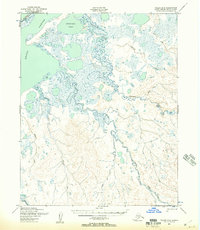
1950 Map of Teller D-4
USGS Topo · Published 1957About this map
The Arctic Lagoon and the complex tidal waters of Kugrupaga Inlet dominate this coastal Seward Peninsula landscape as it appeared at mid-century. Mapping by the Army Map Service reveals a low-lying, water-logged terrain defined by the winding courses of the Nuluk River and Kugrupaga River. A notable human element is the Winter Trail, which skims the northern edge of the lagoon, indicating the seasonal transportation routes vital for navigating this subarctic region before more permanent infrastructure arrived. The interior is a dense network of drainage systems, including Tuttle Creek, California Creek, and Trout Creek, flowing through varied elevations. Further south, the map details the headwaters of the Pinguk River and its tributaries like Cooper Creek, illustrating the natural hydrological patterns of the Second Judicial Division of Alaska.
Find a feature on this map
13 named features on this map. Tap any name to fly to it.
Don’t see what you’re looking for? This feature index may not catch every label — zoom into the map to look around manually.
Map Details
Editions of this 1950 Teller D-4 Map
2 editions found
Other maps of this area

1950 · Teller
USGS Topo · 1:250,000

1950 · Shishmaref
USGS Topo · 1:250,000

1950 · Teller C-3
USGS Topo · 1:63,360

1950 · Teller D-3
USGS Topo · 1:63,360

1950 · Teller D-5
USGS Topo · 1:63,360

1950 · Teller C-4
USGS Topo · 1:63,360
1950 · Shishmaref A-4
USGS Topo · 1:63,360

1950 · Shishmaref A-3
USGS Topo · 1:63,360
1950 · Teller D-4
USGS Topo · 1:63,360

1950 · Teller C-5
USGS Topo · 1:63,360