
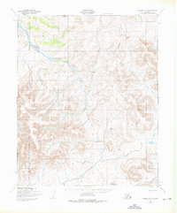
1950 Map of Teller C-3
USGS Topo · Published 1957About this map
The Nuluk River carves through this remote stretch of the Seward Peninsula, forming a central drainage for numerous tributaries like Deep Creek and Maria Cr. Surveyed by the Army Map Service, this terrain illustrates the complex seasonal mobility required in the Alaskan interior during the mid-20th century. The presence of a Winter Trail along the Arctic Creek drainage highlights the established routes used when frozen ground and snowpack transformed the impassable landscape into a navigable corridor. Further south, the confluence of the North Fork and South Fork feeds the main river system, while the eastern reaches are defined by the headwaters of Boulder Creek. This map documents a wilderness landscape largely devoid of permanent settlement, where survival and travel were dictated by the seasonal patterns of the rivers and the harsh Arctic climate.
Find a feature on this map
10 named features on this map. Tap any name to fly to it.
Don’t see what you’re looking for? This feature index may not catch every label — zoom into the map to look around manually.
Map Details
Editions of this 1950 Teller C-3 Map
2 editions found
Other maps of this area

1950 · Teller
USGS Topo · 1:250,000

1950 · Teller B-4
USGS Topo · 1:63,360

1950 · Teller B-2
USGS Topo · 1:63,360

1950 · Teller D-2
USGS Topo · 1:63,360

1950 · Teller D-3
USGS Topo · 1:63,360

1950 · Teller C-4
USGS Topo · 1:63,360

1950 · Teller C-2
USGS Topo · 1:63,360

1950 · Teller B-3
USGS Topo · 1:63,360
1950 · Teller D-4
USGS Topo · 1:63,360

1951 · Teller
USGS Topo · 1:250,000