
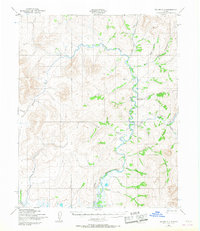
1950 Map of Teller C-2
USGS Topo · Published 1957About this map
The American River winds through this terrain in the Second Judicial Division, defining a landscape marked by early logistical and industrial efforts. Detailed during the mid-century, the map reveals a network of transport routes including a Winter Trail and a Tractor Trail that supported movement across the interior. Of particular interest is the Ottumwa Ditch, a feature suggesting significant hydraulic activity or mining infrastructure in the vicinity of Budd Creek. A remote Landing Strip and a lonely Cabin underscore the isolation of the region during the 1950s. The drainage pattern is heavily documented, with numerous named tributaries such as Goldrun Creek, Wilson Creek, and Peasley Creek flowing toward the main river valley. This survey provides a precise view of the geographic character before extensive modern development, capturing the essential infrastructure of a working frontier.
Find a feature on this map
22 named features on this map. Tap any name to fly to it.
Don’t see what you’re looking for? This feature index may not catch every label — zoom into the map to look around manually.
Map Details
Editions of this 1950 Teller C-2 Map
2 editions found
Other maps of this area

1950 · Teller
USGS Topo · 1:250,000

1950 · Teller B-2
USGS Topo · 1:63,360

1950 · Teller C-3
USGS Topo · 1:63,360

1950 · Teller B-1
USGS Topo · 1:63,360

1950 · Teller D-2
USGS Topo · 1:63,360

1950 · Teller D-3
USGS Topo · 1:63,360

1950 · Teller B-3
USGS Topo · 1:63,360

1950 · Teller D-1
USGS Topo · 1:63,360
1950 · Teller C-1
USGS Topo · 1:63,360

1951 · Teller
USGS Topo · 1:250,000