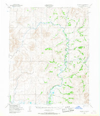
1950 Map of Teller C-2
USGS Topo · Published 1967About this map
American River and the Kougarok River dominate this interior landscape of the Seward Peninsula, recorded from aerial photography taken at the midpoint of the twentieth century. The map highlights the infrastructure of remote transit and resource extraction, specifically the Ottumwa Ditch, a significant water conveyance system for mining operations. Unlike more settled regions, human presence here is marked by functional landmarks rather than towns, including an isolated Cabin and a remote Landing Strip used for bush pilot access. Overland travel relied on a network of seasonal routes, such as the Winter Trail and several stretches of Tractor Trail that follow the natural drainage of Portage Creek and Budd Creek. Numerous named tributaries like Goldrun Creek and Peasley Creek suggest a landscape heavily prospected and traversed during the era of gold exploration and territorial development.
Find a feature on this map
21 named features on this map. Tap any name to fly to it.
Don’t see what you’re looking for? This feature index may not catch every label — zoom into the map to look around manually.
Map Details
Editions of this 1950 Teller C-2 Map
2 editions found
Other maps of this area

1950 · Teller
USGS Topo · 1:250,000

1950 · Teller B-2
USGS Topo · 1:63,360

1950 · Teller C-3
USGS Topo · 1:63,360

1950 · Teller B-1
USGS Topo · 1:63,360

1950 · Teller D-2
USGS Topo · 1:63,360

1950 · Teller D-3
USGS Topo · 1:63,360

1950 · Teller C-2
USGS Topo · 1:63,360

1950 · Teller B-3
USGS Topo · 1:63,360

1950 · Teller D-1
USGS Topo · 1:63,360
1950 · Teller C-1
USGS Topo · 1:63,360