
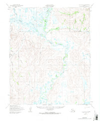
1950 Map of Teller B-2
USGS Topo · Published 1957About this map
The Agiapuk River winds through a vast network of wetlands and tundra in this 1950s study of the Seward Peninsula. This landscape is defined by its complex hydrology, where the American River joins the main channel amidst a sprawling collection of unnamed lakes and marshy flats. The human presence is captured through primitive transportation routes rather than permanent settlements, reflecting the seasonal and industrial movements of the era. A prominent Tractor Trail cuts across the western highlands, while a Winter Trail bypasses the frozen lowlands in the south, likely providing essential passage when the ground was solid enough for heavy equipment. Named tributaries such as Oilfield Creek and Eureka Creek hint at the prospecting and resource interests that drove exploration in this part of the Alaska Territory shortly after the war.
Find a feature on this map
16 named features on this map. Tap any name to fly to it.
Don’t see what you’re looking for? This feature index may not catch every label — zoom into the map to look around manually.
Map Details
Editions of this 1950 Teller B-2 Map
2 editions found
Other maps of this area

1950 · Teller
USGS Topo · 1:250,000

1950 · Teller A-2
USGS Topo · 1:63,360

1950 · Teller A-1
USGS Topo · 1:63,360

1950 · Teller C-3
USGS Topo · 1:63,360

1950 · Teller B-1
USGS Topo · 1:63,360

1950 · Teller A-3
USGS Topo · 1:63,360

1950 · Teller C-2
USGS Topo · 1:63,360

1950 · Teller B-3
USGS Topo · 1:63,360
1950 · Teller C-1
USGS Topo · 1:63,360

1951 · Teller
USGS Topo · 1:250,000