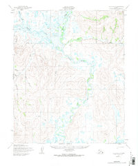
1950 Map of Teller B-2
USGS Topo · Published 1974About this map
The Agiapuk River and its major tributary, the American River, dominate this mid-century survey of the Seward Peninsula. Mapped by the Army Map Service using aerial photography from 1949 and 1950, the landscape is defined by its complex hydraulic network rather than permanent settlements. Transport through this subarctic environment relied heavily on seasonal routes, as evidenced by the network of Tractor Trails and a designated Winter Trail that cut across the drainage basins of Igloo Creek and Mitchell Creek. These trails often follow the natural corridors provided by watercourses like Eureka Creek and Offield Creek, reflecting the importance of overland travel in an era before developed road infrastructure reached this part of Alaska. Small family or mining-named landmarks appear throughout the terrain, including Nickle Creek and Saturday Creek, marking the sparse human footprint on the land.
Find a feature on this map
16 named features on this map. Tap any name to fly to it.
Don’t see what you’re looking for? This feature index may not catch every label — zoom into the map to look around manually.
Map Details
Editions of this 1950 Teller B-2 Map
2 editions found
Other maps of this area

1950 · Teller
USGS Topo · 1:250,000

1950 · Teller A-2
USGS Topo · 1:63,360

1950 · Teller A-1
USGS Topo · 1:63,360

1950 · Teller B-2
USGS Topo · 1:63,360

1950 · Teller C-3
USGS Topo · 1:63,360

1950 · Teller B-1
USGS Topo · 1:63,360

1950 · Teller A-3
USGS Topo · 1:63,360

1950 · Teller C-2
USGS Topo · 1:63,360

1950 · Teller B-3
USGS Topo · 1:63,360
1950 · Teller C-1
USGS Topo · 1:63,360