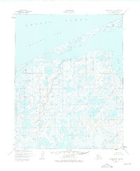
1950 Map of Shishmaref B-1
USGS Topo · Published 1975About this map
The Arctic Ocean shoreline defines this northern landscape, where the cold waters of the Chukchi Sea meet the low-lying coastal plains of the Seward Peninsula. Based on aerial photography from the late 1940s, this survey reveals an intricate network of thaw lakes and wetlands that dominate the terrain inland from the coast. The lack of roads or permanent settlements at mid-century highlights the seasonal and subsistence character of the region. A significant geographical feature is Cowpack Inlet, which cuts into the coastline to the east, providing a drainage point for the winding Cowpack River. This map serves as a vital record of the delicate permafrost landscape and changing Arctic shorelines as they existed before the introduction of modern infrastructure or industrial development in this part of Alaska.
Find a feature on this map
4 named features on this map. Tap any name to fly to it.
Don’t see what you’re looking for? This feature index may not catch every label — zoom into the map to look around manually.
Map Details
Editions of this 1950 Shishmaref B-1 Map
2 editions found
Other maps of this area

1950 · Kotzebue C-6
USGS Topo · 1:63,360

1950 · Shishmaref
USGS Topo · 1:250,000

1950 · Shishmaref A-1
USGS Topo · 1:63,360

1950 · Kotzebue A-6
USGS Topo · 1:63,360

1950 · Shishmaref B-1
USGS Topo · 1:63,360

1950 · Shishmaref A-2
USGS Topo · 1:63,360
1950 · Shishmaref B-2
USGS Topo · 1:63,360

1950 · Kotzebue B-6
USGS Topo · 1:63,360

1951 · Shishmaref
USGS Topo · 1:250,000

1951 · Kotzebue
USGS Topo · 1:250,000