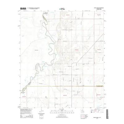
2015 Map of Shoats Creek
USGS Topo · Published 2015About this map
The Sabine River defines the border between Texas and Louisiana in this 2015 survey, winding through a complex system of sloughs and oxbow lakes. This riparian corridor is home to features like Devils Pocket and Boggy Lakes, illustrating the dynamic nature of the river valley. To the east, the landscape transitions into the piney woods of Calcasieu Parish and Beauregard Parish, where the terrain rises toward High Hill. Local family history is well-represented through numerous rural cemeteries, including Clark Cem, Smith Cem, and Carter Cem, which are scattered among a network of local roads such as Cater Settlement RD and Gamble Church RD. The area is further drained by Shoats Creek and Bear Head Cr, providing a detailed look at the drainage patterns of the western Louisiana borderlands in the early 21st century.
Find a feature on this map
75 named features on this map. Tap any name to fly to it.
Don’t see what you’re looking for? This feature index may not catch every label — zoom into the map to look around manually.
Map Details
Editions of this 2015 Shoats Creek Map
This is the sole edition of this map. No revisions or reprints were ever made.
Other maps of this area

1947 · Starks
USGS Topo · 1:31,680

1947 · Carter Creek
USGS Topo · 1:31,680

1947 · Hyatt
USGS Topo · 1:31,680

1947 · Lunita
USGS Topo · 1:31,680

1947 · Long Marsh
USGS Topo · 1:31,680

1949 · Bancroft
USGS Topo · 1:31,680

1952 · Lake Charles
USGS Topo · 1:250,000

1954 · Lake Charles
USGS Topo · 1:250,000
1955 · Hyatt
USGS Topo · 1:31,680

1955 · Bessmay
USGS Topo · 1:62,500