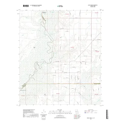
2018 Map of Shoats Creek
USGS Topo · Published 2018About this map
The Sabine River forms a complex labyrinth of oxbows and swampy lowlands along the Texas-Louisiana border, creating a landscape defined by seasonal water and shifting boundaries. Dense networks of backwater features like Dead Lake, Big Eddy Lake, and Horseshoe Lake dominate the western portion of the quadrangle, while the elevation rises slightly toward the east. This transition into Calcasieu Parish and Beauregard Parish reveals a history of rural settlement tied to the land and family lineages. Small family burial grounds such as Smith Cem and Clark Cems are tucked away near the river's influence, illustrating the long-standing human presence in this fluvial environment.
Find a feature on this map
78 named features on this map. Tap any name to fly to it.
Don’t see what you’re looking for? This feature index may not catch every label — zoom into the map to look around manually.
Map Details
Editions of this 2018 Shoats Creek Map
This is the sole edition of this map. No revisions or reprints were ever made.
Other maps of this area

1947 · Starks
USGS Topo · 1:31,680

1947 · Carter Creek
USGS Topo · 1:31,680

1947 · Hyatt
USGS Topo · 1:31,680

1947 · Lunita
USGS Topo · 1:31,680

1947 · Long Marsh
USGS Topo · 1:31,680

1949 · Bancroft
USGS Topo · 1:31,680

1952 · Lake Charles
USGS Topo · 1:250,000

1954 · Lake Charles
USGS Topo · 1:250,000
1955 · Hyatt
USGS Topo · 1:31,680

1955 · Bessmay
USGS Topo · 1:62,500