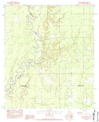
1982 Map of Shoats Creek
USGS Topo · Published 1983About this map
The Sabine River serves as the winding centerpiece for this Louisiana and Texas borderlands landscape, defining the jagged boundary between Newton County and Beauregard Parish. This floodplain environment is characterized by a complex network of oxbow lakes and bypass channels, including Dead Lake, China Lake, and the distinctive Horseshoe Lake. The dense concentration of sloughs, such as Alligator Slough and Cole Slough, indicates a terrain shaped by the historical migrations of the river, creating a unique pocket of bottomland known as Devils Pocket.
Find a feature on this map
43 named features on this map. Tap any name to fly to it.
Don’t see what you’re looking for? This feature index may not catch every label — zoom into the map to look around manually.
Map Details
Editions of this 1982 Shoats Creek Map
This is the sole edition of this map. No revisions or reprints were ever made.
Other maps of this area

1947 · Starks
USGS Topo · 1:31,680

1947 · Carter Creek
USGS Topo · 1:31,680

1947 · Hyatt
USGS Topo · 1:31,680

1947 · Lunita
USGS Topo · 1:31,680

1947 · Long Marsh
USGS Topo · 1:31,680

1949 · Bancroft
USGS Topo · 1:31,680

1952 · Lake Charles
USGS Topo · 1:250,000

1954 · Lake Charles
USGS Topo · 1:250,000
1955 · Hyatt
USGS Topo · 1:31,680

1955 · Bessmay
USGS Topo · 1:62,500