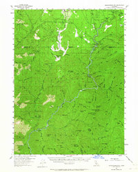
1954 Map of Shoeinhorse Mountain
USGS Topo · Published 1964About this map
The McCloud River snakes through this mid-century survey of the Shasta National Forest, a landscape defined by its complex drainage network and isolated outpost settlements. Historical markers of early 20th-century estate and resort life appear along the riverbanks, including the Hearst-owned Wyntoon and the McCloud River Club. Further south, Ah-Di-Na sits at the base of a sharp river bend near Ash Camp, representing the deep history of habitation in this mountainous region. The terrain is characterized by numerous named buttes and peaks, such as Shoeinhorse Mtn and Bald Mtn, and idiosyncratic place names like the Happy Hunting Grounds. Transportation is limited to a handful of primary routes and a Jeep Trail, emphasizing the area's role as a timber and recreation resource rather than an urban center.
Find a feature on this map
106 named features on this map. Tap any name to fly to it.
Don’t see what you’re looking for? This feature index may not catch every label — zoom into the map to look around manually.
Map Details
Editions of this 1954 Shoeinhorse Mountain Map
3 editions found

Other maps of this area

1886 · Lassen Peak
USGS Topo · 1:250,000

1886 · Modoc Lava Bed
USGS Topo · 1:250,000

1886 · Shasta
USGS Topo · 1:250,000

1890 · Red Bluff
USGS Topo · 1:250,000

1892 · Modoc Lava-Bed
USGS Topo · 1:250,000

1892 · Lassen Peak
USGS Topo · 1:250,000

1894 · Lassen Peak
USGS Topo · 1:250,000

1894 · Red Bluff
USGS Topo · 1:250,000

1894 · Shasta
USGS Topo · 1:250,000

1901 · Redding
USGS Topo · 1:125,000