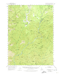
1954 Map of Shoeinhorse Mountain
USGS Topo · Published 1974About this map
The McCloud River carves through the heart of this mid-century Shasta County landscape, serving as the primary corridor for remote camps and private retreats. The map documents established riverfront enclaves such as Wyntoon and the McCloud River Club, alongside utilitarian sites like Rinckel and various gaging stations. High-elevation landmarks define the surrounding terrain, including the eponymous Shoeinhorse Mtn and the neighboring Little Shoeinhorse Mountain.
Find a feature on this map
119 named features on this map. Tap any name to fly to it.
Don’t see what you’re looking for? This feature index may not catch every label — zoom into the map to look around manually.
Map Details
Editions of this 1954 Shoeinhorse Mountain Map
3 editions found

Other maps of this area

1886 · Lassen Peak
USGS Topo · 1:250,000

1886 · Modoc Lava Bed
USGS Topo · 1:250,000

1886 · Shasta
USGS Topo · 1:250,000

1890 · Red Bluff
USGS Topo · 1:250,000

1892 · Modoc Lava-Bed
USGS Topo · 1:250,000

1892 · Lassen Peak
USGS Topo · 1:250,000

1894 · Lassen Peak
USGS Topo · 1:250,000

1894 · Red Bluff
USGS Topo · 1:250,000

1894 · Shasta
USGS Topo · 1:250,000

1901 · Redding
USGS Topo · 1:125,000