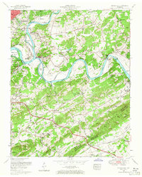
1953 Map of Shooks Gap
USGS Topo · Published 1965About this map
The French Broad River and Holston River converge here to form the Tennessee River, a defining hydrological junction that shaped the development of eastern Knoxville during the mid-20th century. This 1953 survey by the Tennessee Valley Authority and USGS reveals a landscape in transition, where the river-bottom farms of Pickel Island and the Eastern State Hospital Farm sit adjacent to expanding residential areas like Lake Forest and Burlington. The map captures the industrial foundations of the region, including the Meades Quarry and Neubert Quarry, alongside the early aviation infrastructure at the Island Airport. Local social and spiritual life is anchored by numerous small community hubs, from the Huckleberry Springs Church in the northeast to Shooks and Neubert in the south. The presence of Bays Mountain and Sharp Ridge dictates the winding path of the Southern Railway, while the developing Chapman Highway signals the era's shift toward increased automobile mobility.
Find a feature on this map
109 named features on this map. Tap any name to fly to it.
Don’t see what you’re looking for? This feature index may not catch every label — zoom into the map to look around manually.
Map Details
Editions of this 1953 Shooks Gap Map
3 editions found
Other maps of this area

1886 · Knoxville
USGS Topo · 1:125,000

1892 · Knoxville
USGS Topo · 1:125,000

1894 · Knoxville
USGS Topo · 1:125,000

1895 · Knoxville
USGS Topo · 1:125,000

1897 · Maynardville
USGS Topo · 1:125,000

1900 · Maynardville
USGS Topo · 1:125,000

1901 · Knoxville
USGS Topo · 1:125,000

1935 · Mascot
USGS Topo · 1:24,000

1935 · Knoxville
USGS Topo · 1:48,000

1935 · Straw Plains
USGS Topo · 1:48,000