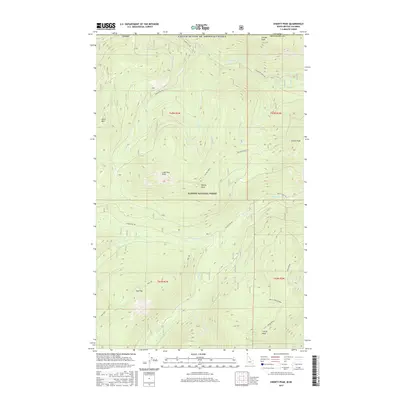
2017 Map of Shorty Peak
USGS Topo · Published 2017About this map
The international border between the United States of America and Canada defines the northern edge of this high-elevation landscape within Kaniksu National Forest. Dominated by the subalpine terrain of the Selkirk Mountains, the area centers on Shorty Peak and surrounding summits like Lone Tree Peak, Italian Peak, and Silver Mtn. This interior mountain environment is shaped by a network of drainage systems, including Boundary Creek and Smith Creek, which flow through steep valleys separated by prominent landforms like Italian Ridge and Smith Creek Ridge. Human presence is marked by a handful of remote access routes such as Saddle Pass Rd and Boundary Creek Rd. This map captures the intersection of political boundaries and physical geography, showing how national forest lands in Boundary Co interact with the Canadian frontier through a series of ridges and peaks.
Find a feature on this map
32 named features on this map. Tap any name to fly to it.
Don’t see what you’re looking for? This feature index may not catch every label — zoom into the map to look around manually.
Map Details
Editions of this 2017 Shorty Peak Map
This is the sole edition of this map. No revisions or reprints were ever made.
Other maps of this area

1911 · Priest Lake
USGS Topo · 1:250,000

1913 · Priest Lake
USGS Topo · 1:250,000

1958 · Sandpoint
USGS Topo · 1:250,000

1963 · Sandpoint
USGS Topo · 1:250,000

1968 · Smith Falls
USGS Topo · 1:24,000

1969 · Grass Mountain
USGS Topo · 1:24,000
1969 · Caribou Creek
USGS Topo · 1:24,000

1969 · Pyramid Peak
USGS Topo · 1:24,000
1969 · Shorty Peak
USGS Topo · 1:24,000
1969 · Smith Peak
USGS Topo · 1:24,000