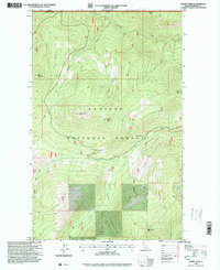
1996 Map of Shorty Peak
USGS Topo · Published 1999About this map
Kaniksu National Forest defines this high-altitude landscape along the international border, where the Canada United States boundary meets the line between British Columbia and Idaho. The map documents a network of high mountain peaks and drainages, including the prominent Shorty Peak Lookout and Red Top Lookout, which served as vital observation points for forest management. Waterways like Boundary Creek and Smith Creek carve through the terrain, while the secluded Canyon Lake sits in the southeastern reaches. A system of 4wd tracks and trails provides the only access to these summits and the USFS Camp 126. The topography reflects a period of intensive forest service oversight in the late twentieth century, focusing on fire prevention and remote access in the Selkirk Mountains region.
Find a feature on this map
22 named features on this map. Tap any name to fly to it.
Don’t see what you’re looking for? This feature index may not catch every label — zoom into the map to look around manually.
Map Details
Editions of this 1996 Shorty Peak Map
This is the sole edition of this map. No revisions or reprints were ever made.
Other maps of this area

1911 · Priest Lake
USGS Topo · 1:250,000

1913 · Priest Lake
USGS Topo · 1:250,000

1958 · Sandpoint
USGS Topo · 1:250,000

1963 · Sandpoint
USGS Topo · 1:250,000

1968 · Smith Falls
USGS Topo · 1:24,000

1969 · Grass Mountain
USGS Topo · 1:24,000
1969 · Caribou Creek
USGS Topo · 1:24,000

1969 · Pyramid Peak
USGS Topo · 1:24,000
1969 · Shorty Peak
USGS Topo · 1:24,000
1969 · Smith Peak
USGS Topo · 1:24,000