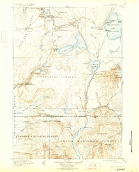
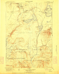
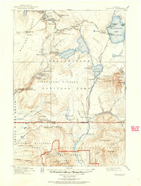
1911 Map of Shoshone
USGS Topo · Published 1927About this map
The Upper Geyser Basin is the focal point of this 1910-era survey, capturing the early infrastructure of American wilderness tourism. Early hospitality sites like the Old Faithful Inn and the Old Faithful Permanent Camp appear alongside the world-famous Old Faithful geyser and the Giantess Geyser. The landscape is defined by the high elevations of the Madison Plateau and Pitchstone Plateau, with the Continental Divide winding between Shoshone Lake and the West Thumb of Yellowstone Lake. Remote outposts such as Snowshoe Cabin and Sheffield Camp mark the transition into the Targhee National Forest and Teton National Forest. The presence of the Old Faithful Road and the Cascade Roadhouse illustrates the primary travel routes used by early visitors to the park before modern highway expansion.
Find a feature on this map
108 named features on this map. Tap any name to fly to it.
Don’t see what you’re looking for? This feature index may not catch every label — zoom into the map to look around manually.
Map Details
Editions of this 1911 Shoshone Map
3 editions found
Other maps of this area

1885 · Lake
USGS Topo · 1:125,000

1885 · Gallatin
USGS Topo · 1:125,000

1885 · Gallatin
USGS Topo · 1:125,000

1886 · Shoshone
USGS Topo · 1:125,000

1886 · Canyon
USGS Topo · 1:125,000

1888 · Shoshone
USGS Topo · 1:125,000

1895 · Shoshone
USGS Topo · 1:125,000

1895 · Canyon
USGS Topo · 1:125,000

1895 · Lake
USGS Topo · 1:125,000

1896 · Lake
USGS Topo · 1:125,000