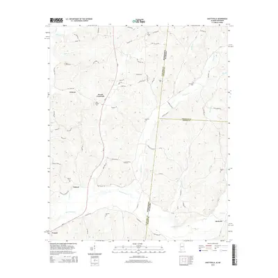
2014 Map of Shottsville
USGS Topo · Published 2014About this map
Bull Mountain Creek and its many tributaries, including Cypress Creek and McConegal Creek, carve a detailed drainage network across the border of Mississippi and Alabama. This landscape is defined by its small, dispersed settlements like Shottsville, Oakland, and Bounds Crossroads, reflecting a rural community structure rooted in local agriculture and family ties. A high density of burial sites, such as Pates Temple Cemetery, Hopewell Cemetery, and Providence Cemetery, provides significant data for genealogical research in both Itawamba and Marion counties. The geography is further marked by the proximity of State Highway 23 and numerous named rural routes like Doc Pearson Road, which connect these small crossroads and hamlets across the state line.
Find a feature on this map
79 named features on this map. Tap any name to fly to it.
Don’t see what you’re looking for? This feature index may not catch every label — zoom into the map to look around manually.
Map Details
Editions of this 2014 Shottsville Map
This is the sole edition of this map. No revisions or reprints were ever made.
Other maps of this area

1936 · Red Bay
USGS Topo · 1:24,000

1936 · Vina
USGS Topo · 1:24,000

1936 · Halltown
USGS Topo · 1:24,000

1950 · Vina
USGS Topo · 1:24,000
1950 · Halltown
USGS Topo · 1:24,000

1951 · Vina
USGS Topo · 1:24,000

1951 · Red Bay
USGS Topo · 1:24,000
1951 · Halltown
USGS Topo · 1:24,000

1956 · Tupelo
USGS Topo · 1:250,000

1958 · Tupelo
USGS Topo · 1:250,000