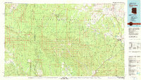
1981 Map of Show Low
USGS Topo · Published 1982About this map
The Mogollon Rim dominates this 1981 survey, serving as a massive geological boundary that separates the high plateau of the Sitgreaves National Forest from the lower canyons of the Tonto National Forest and the Fort Apache Indian Reservation. The map captures the growing mountain communities of Show Low, Snowflake, and Taylor during a period of transition, where established timber and ranching routes like Highway 260 intersect with the legacy of the Apache Ry.
Find a feature on this map
77 named features on this map. Tap any name to fly to it.
Don’t see what you’re looking for? This feature index may not catch every label — zoom into the map to look around manually.
Map Details
Editions of this 1981 Show Low Map
2 editions found
Other maps of this area

1886 · St Johns
USGS Topo · 1:250,000

1886 · Holbrook
USGS Topo · 1:250,000

1887 · Verde
USGS Topo · 1:250,000

1892 · Verde
USGS Topo · 1:250,000

1892 · St Johns
USGS Topo · 1:250,000

1893 · Holbrook
USGS Topo · 1:250,000

1907 · Roosevelt
USGS Topo · 1:125,000

1909 · Four Peaks
USGS Topo · 1:125,000

1912 · Roosevelt
USGS Topo · 1:125,000

1922 · Chrysotile
USGS Topo · 1:125,000