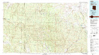
1981 Map of Show Low
USGS Topo · Published 1982About this map
The dramatic geography of the Mogollon Rim dominates this landscape, serving as a massive topographical break between the high plateaus and the rugged canyonlands below. Within the Sitgreaves National Forest, the map traces the early development of Show Low and Snowflake, while the southern reaches descend into the Fort Apache Indian Reservation. The terrain is deeply incised by drainages like Chevelon Creek and Cibecue Creek, which define the movement of early settlers and indigenous communities. From the small community of Heber in the west to the cattle-country outposts of Shumway and Forestdale, the map documents a region defined by its timber and ranching history. Remote settlements such as Grasshopper and Cibecue appear as isolated centers of activity connected by early alignments of Route 60 and Route 260.
Find a feature on this map
52 named features on this map. Tap any name to fly to it.
Don’t see what you’re looking for? This feature index may not catch every label — zoom into the map to look around manually.
Map Details
Editions of this 1981 Show Low Map
2 editions found
Other maps of this area

1886 · St Johns
USGS Topo · 1:250,000

1886 · Holbrook
USGS Topo · 1:250,000

1887 · Verde
USGS Topo · 1:250,000

1892 · Verde
USGS Topo · 1:250,000

1892 · St Johns
USGS Topo · 1:250,000

1893 · Holbrook
USGS Topo · 1:250,000

1907 · Roosevelt
USGS Topo · 1:125,000

1909 · Four Peaks
USGS Topo · 1:125,000

1912 · Roosevelt
USGS Topo · 1:125,000

1922 · Chrysotile
USGS Topo · 1:125,000