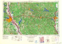
1984 Map of Shreveport
USGS Topo · Published 1984About this map
Barksdale Air Force Base stands as a prominent military installation near Shreveport and Bossier City, anchoring the western edge of a landscape defined by the winding Red River. This 1984 survey reveals a region deeply tied to its natural resources, with extensive energy extraction sites like the Monroe Gas Field and Rodessa Oil and Gas Field dotting the northern and eastern parishes. Between these industrial hubs, the terrain rises toward Driskell Mountain and the Kisatchie Hills, where the Kisatchie National Forest preserves significant woodland tracts.
Find a feature on this map
205 named features on this map. Tap any name to fly to it.
Don’t see what you’re looking for? This feature index may not catch every label — zoom into the map to look around manually.
Map Details
Editions of this 1984 Shreveport Map
2 editions found

Other maps of this area

1907 · Atlanta
USGS Topo · 1:62,500

1910 · Atlanta
USGS Topo · 1:62,500

1922 · Sarepta
USGS Topo · 1:62,500

1924 · Sarepta
USGS Topo · 1:62,500

1927 · El Dorado
USGS Topo · 1:62,500

1930 · El Dorado
USGS Topo · 1:62,500

1932 · Hosston NW
USGS Topo · 1:31,680

1932 · Bossier SE
USGS Topo · 1:31,680

1932 · Hosston NE
USGS Topo · 1:31,680

1932 · Bossier NE
USGS Topo · 1:31,680