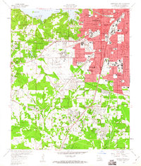
1959 Map of Shreveport West
USGS Topo · Published 1960About this map
Shreveport transitions from a dense urban grid into the western piney woods of Caddo Parish on this late 1950s survey. The landscape is defined by its rapid postwar expansion, evidenced by the numerous schools like Fair Park High Sch and Lake Shore Jr High Sch serving growing neighborhoods. The State Fairground anchors the city's western edge, while the massive Greater Shreveport Municipal Airport dominates the central terrain.
Find a feature on this map
68 named features on this map. Tap any name to fly to it.
Don’t see what you’re looking for? This feature index may not catch every label — zoom into the map to look around manually.
Map Details
Editions of this 1959 Shreveport West Map
2 editions found
Other maps of this area

1932 · Bossier SW
USGS Topo · 1:31,680

1932 · Shreveport SE
USGS Topo · 1:31,680

1941 · Forbing
USGS Topo · 1:31,680

1945 · Greenwood
USGS Topo · 1:62,500

1948 · Mooringsport
USGS Topo · 1:62,500

1948 · Bossier City
USGS Topo · 1:62,500

1948 · Caspiana
USGS Topo · 1:62,500

1955 · Shreveport
USGS Topo · 1:250,000
1955 · Bossier City
USGS Topo · 1:24,000

1955 · Shreveport East
USGS Topo · 1:24,000