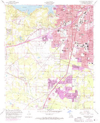
1959 Map of Shreveport West
USGS Topo · Published 1969About this map
The western expansion of Shreveport is captured during a period of significant mid-century growth, as urban residential areas began to push into the rural landscapes of western Louisiana. The map detail highlights an extensive network of schools and civic institutions serving new neighborhoods like Jewella, Caddo Heights, and Summer Grove. This era of development is juxtaposed with the established industrial and transit infrastructure, including the Texas and Pacific and Kansas City Southern railroads. To the north, Cross Lake and Ford Park define the recreational edge of the city, while the Municipal Airport and the State Fairground reflect the city's role as a regional hub. Local history is deeply preserved in the many cemeteries like Hebrew Rest Cem and Star Cem, alongside numerous community churches that anchored these evolving suburban and industrial districts.
Find a feature on this map
57 named features on this map. Tap any name to fly to it.
Don’t see what you’re looking for? This feature index may not catch every label — zoom into the map to look around manually.
Map Details
Editions of this 1959 Shreveport West Map
2 editions found
Other maps of this area

1932 · Bossier SW
USGS Topo · 1:31,680

1932 · Shreveport SE
USGS Topo · 1:31,680

1941 · Forbing
USGS Topo · 1:31,680

1945 · Greenwood
USGS Topo · 1:62,500

1948 · Mooringsport
USGS Topo · 1:62,500

1948 · Bossier City
USGS Topo · 1:62,500

1948 · Caspiana
USGS Topo · 1:62,500

1955 · Shreveport
USGS Topo · 1:250,000
1955 · Bossier City
USGS Topo · 1:24,000

1955 · Shreveport East
USGS Topo · 1:24,000