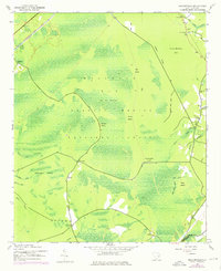
1943 Map of Shulerville
USGS Topo · Published 1976About this map
Hellhole Bay dominates the interior of this coastal South Carolina landscape, a massive wetland basin within the Francis Marion National Forest. The map documents a scattered rural settlement pattern at the edge of the swamp, anchored by local crossroads like Farewell Corner, Oak Corner, and Thomas Corner. To the northeast, the community of Shulerville serves as a small hub, supported by a Post Office and nearby spiritual centers including Bethany Ch and Newhope Ch.
Find a feature on this map
34 named features on this map. Tap any name to fly to it.
Don’t see what you’re looking for? This feature index may not catch every label — zoom into the map to look around manually.
Map Details
Editions of this 1943 Shulerville Map
2 editions found
Other maps of this area

1919 · Cordesville
USGS Topo · 1:48,000

1942 · Cedar Creek
USGS Topo · 1:24,000

1942 · Honey Hill
USGS Topo · 1:24,000

1943 · Shulerville
USGS Topo · 1:24,000

1943 · Jamestown
USGS Topo · 1:24,000

1943 · Awendaw
USGS Topo · 1:24,000

1943 · Ocean Bay
USGS Topo · 1:24,000

1943 · Bonneau
USGS Topo · 1:62,500

1948 · Bethera
USGS Topo · 1:24,000

1949 · Georgetown
USGS Topo · 1:250,000