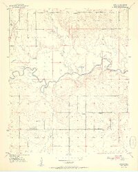
1951 Map of Shults
USGS Topo · Published 1951About this map
The Little River carves a winding path through this corner of McCurtain County, defining the landscape just after the mid-century mark. The rural character of the era is evidenced by a network of small, localized communities and gathering places like Shults, Redland, and the Welch Store. These small nodes of activity are linked by unimproved roads and the tracks of the S L & S F R R, which cuts through the northwestern section near Hill Chapel.
Find a feature on this map
23 named features on this map. Tap any name to fly to it.
Don’t see what you’re looking for? This feature index may not catch every label — zoom into the map to look around manually.
Map Details
Editions of this 1951 Shults Map
2 editions found

Other maps of this area

1902 · Lukfata
USGS Topo · 1:125,000

1950 · Mcalester
USGS Topo · 1:250,000

1950 · Idabel
USGS Topo · 1:24,000

1950 · Shults
USGS Topo · 1:24,000

1950 · Haworth
USGS Topo · 1:24,000

1950 · Goodwater
USGS Topo · 1:24,000

1950 · Bokhoma
USGS Topo · 1:24,000

1951 · Idabel
USGS Topo · 1:24,000

1951 · Idabel SE
USGS Topo · 1:24,000

1951 · Haworth
USGS Topo · 1:24,000