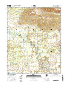
2016 Map of Shungnak A-2 SW
USGS Topo · Published 2016About this map
Billy Hawk Creek defines the hydrological character of this landscape, winding through a complex network of oxbow lakes and meander scars. This 2016 survey captures the transition from the high relief of the northern hills to the low-lying wetlands of the interior river valleys. The intricate patterns of water and land in the southern half of the map illustrate a highly dynamic alluvial environment where the creek has shifted its course repeatedly over time. The Public Land Survey System grid, including t8n r9e, t8n r10e, t7n r9e, and t7n r10e, provides the primary structural framework for navigating this remote and largely unpopulated territory in the Yukon-Koyukuk region.
Find a feature on this map
5 named features on this map. Tap any name to fly to it.
Don’t see what you’re looking for? This feature index may not catch every label — zoom into the map to look around manually.
Map Details
Editions of this 2016 Shungnak A-2 SW Map
This is the sole edition of this map. No revisions or reprints were ever made.
Other maps of this area

1951 · Shungnak
USGS Topo · 1:250,000

1951 · Kateel River
USGS Topo · 1:250,000

1954 · Kateel River D-3
USGS Topo · 1:63,360

1955 · Shungnak
USGS Topo · 1:250,000

1955 · Kateel River D-2
USGS Topo · 1:63,360

1955 · Kateel River
USGS Topo · 1:250,000

1964 · Shungnak
USGS Topo · 1:250,000
1985 · Shungnak A-3
USGS Topo · 1:63,360
1985 · Shungnak A-2
USGS Topo · 1:63,360
2016 · Kateel River D-2 NE
USGS Topo · 1:25,000