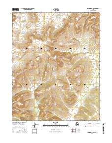
2016 Map of Shungnak A-4 NW
USGS Topo · Published 2016About this map
The Continental Divide winds through this section of the Alaskan wilderness, marking the fundamental hydrological boundary of the continent. This high-altitude terrain is characterized by the headwaters of Ingruksukruk Cr, which flows through the northern reaches of the survey area. The landscape is defined by its position on the administrative border between the Northwest Arctic Borough and the Yukon-Koyukuk Census Area. Mapping by the U.S. Geological Survey and the Alaska Dept. of Transportation reveals a remote and largely undeveloped geography where natural contours dictate the flow of water and the path of the divide itself, offering a clear view of the untouched interior landscape at the start of the twenty-first century.
Find a feature on this map
9 named features on this map. Tap any name to fly to it.
Don’t see what you’re looking for? This feature index may not catch every label — zoom into the map to look around manually.
Map Details
Editions of this 2016 Shungnak A-4 NW Map
This is the sole edition of this map. No revisions or reprints were ever made.
Other maps of this area

1951 · Shungnak
USGS Topo · 1:250,000

1955 · Shungnak
USGS Topo · 1:250,000

1964 · Shungnak
USGS Topo · 1:250,000

1985 · Shungnak B-4
USGS Topo · 1:63,360
1985 · Shungnak A-5
USGS Topo · 1:63,360
1985 · Shungnak A-4
USGS Topo · 1:63,360
1985 · Shungnak B-5
USGS Topo · 1:63,360
2016 · Shungnak B-5 SE
USGS Topo · 1:25,000
2016 · Shungnak A-5 NE
USGS Topo · 1:25,000
2016 · Shungnak A-5 SE
USGS Topo · 1:25,000