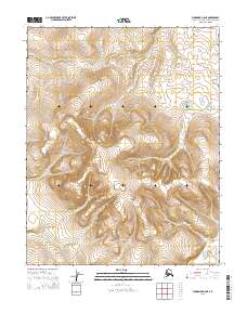
2015 Map of Shungnak A-6 NE
USGS Topo · Published 2015About this map
Ekiek Cr marks the northwest corner of this remote Alaskan landscape, where the terrain rises from the creek bed to a massive central upland. This 2015 survey of the Northwest Arctic region is primarily defined by the intersection of multiple township and range lines, including t10n r1e, t10n r2e, t9n r1e, and t9n r2e. The contour lines illustrate a significant topographic rise reaching across the central portion of the map, suggesting a high-altitude wilderness typical of the Brooks Range foothills. The absence of roads or structures highlights the isolation of this Arctic territory, where the natural drainage of Ekiek Cr remains the primary named landmark for navigation or environmental study.
Find a feature on this map
7 named features on this map. Tap any name to fly to it.
Don’t see what you’re looking for? This feature index may not catch every label — zoom into the map to look around manually.
Map Details
Editions of this 2015 Shungnak A-6 NE Map
This is the sole edition of this map. No revisions or reprints were ever made.
Other maps of this area

1951 · Shungnak
USGS Topo · 1:250,000

1955 · Shungnak
USGS Topo · 1:250,000

1964 · Shungnak
USGS Topo · 1:250,000
1985 · Shungnak B-6
USGS Topo · 1:63,360
1985 · Shungnak A-5
USGS Topo · 1:63,360
1985 · Shungnak A-6
USGS Topo · 1:63,360
1985 · Shungnak B-5
USGS Topo · 1:63,360
2015 · Shungnak B-6 SE
USGS Topo · 1:25,000
2015 · Shungnak A-6 NW
USGS Topo · 1:25,000
2015 · Shungnak A-6 SE
USGS Topo · 1:25,000