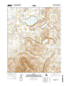
2015 Map of Shungnak B-6 SE
USGS Topo · Published 2015About this map
The Northwest Arctic Borough, as shown in this 2015 study, consists of an intricate network of unnamed lakes and high-elevation terrain organized by the Public Land Survey System. The area is defined by the intersections of T11n R1e, T11n R2e, T10n R1e, and T10n R2e. This landscape is primarily hydrologic, dominated by several large, unnamed bodies of water in the northern sections, while the southern half of the map rises into steep, densely contoured elevations. Without named settlements, roads, or structures, the map serves as a detailed record of the natural state of the Alaskan interior at the start of the 21st century. It highlights the vast, untouched geography that characterizes this remote region of the state.
Find a feature on this map
4 named features on this map. Tap any name to fly to it.
Don’t see what you’re looking for? This feature index may not catch every label — zoom into the map to look around manually.
Map Details
Editions of this 2015 Shungnak B-6 SE Map
This is the sole edition of this map. No revisions or reprints were ever made.
Other maps of this area

1951 · Shungnak
USGS Topo · 1:250,000

1955 · Shungnak
USGS Topo · 1:250,000

1964 · Shungnak
USGS Topo · 1:250,000
1985 · Shungnak B-6
USGS Topo · 1:63,360
1985 · Shungnak A-5
USGS Topo · 1:63,360
1985 · Shungnak A-6
USGS Topo · 1:63,360
1985 · Shungnak B-5
USGS Topo · 1:63,360
2015 · Shungnak A-6 NE
USGS Topo · 1:25,000
2015 · Shungnak A-6 NW
USGS Topo · 1:25,000
2015 · Shungnak B-6 SW
USGS Topo · 1:25,000