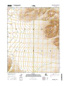
2016 Map of Shungnak B-2 NE
USGS Topo · Published 2016About this map
The Selawik River winds through this expanse of northwestern Alaska, marking a significant hydrological feature in a landscape defined by its subtle elevation changes and vast wetlands. This 2016 survey documents the administrative boundary between the Northwest Arctic Borough and the Yukon-Koyukuk Census Area, a line that cuts across the wilderness near the river's path. The topography is meticulously detailed through contour intervals that reveal the gradual transition from the river valley into the surrounding highlands of the t13n r11e and t12n r11e townships. This map provides a precise record of the natural terrain and jurisdictional borders in a region where few permanent man-made structures exist, making the water systems and township lines the primary landmarks for navigation and land management.
Find a feature on this map
8 named features on this map. Tap any name to fly to it.
Don’t see what you’re looking for? This feature index may not catch every label — zoom into the map to look around manually.
Map Details
Editions of this 2016 Shungnak B-2 NE Map
This is the sole edition of this map. No revisions or reprints were ever made.
Other maps of this area

1951 · Shungnak
USGS Topo · 1:250,000

1955 · Shungnak
USGS Topo · 1:250,000

1964 · Shungnak
USGS Topo · 1:250,000
1985 · Shungnak B-1
USGS Topo · 1:63,360
1985 · Shungnak C-1
USGS Topo · 1:63,360
1985 · Shungnak B-2
USGS Topo · 1:63,360
1985 · Shungnak C-2
USGS Topo · 1:63,360
2016 · Shungnak B-1 SW
USGS Topo · 1:25,000
2016 · Shungnak B-2 SW
USGS Topo · 1:25,000
2016 · Shungnak B-2 SE
USGS Topo · 1:25,000