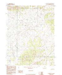
1985 Map of Shungnak C-4
USGS Topo · Published 1986About this map
Selawik National Wildlife Refuge encompasses a significant portion of this Arctic landscape, reflecting federal conservation efforts established by the Alaska National Interest Lands Conservation Act of 1980. The terrain is defined by two prominent uplands: the Sheklukshuk Range in the north and the Kiliovilik Range in the southeast. Between these heights, the Rabbit River meanders through a complex network of wetlands and perennial streams, eventually joined by Kiliovilik Creek. This 1985 provisional survey, compiled from aerial photography taken in 1971, illustrates an area devoid of roads or trails, preserving the remote character of the Northwest Arctic. The absence of human-built infrastructure highlights the primitive state of the region during the late twentieth century, where drainage patterns and topographic contours provide the only navigational landmarks.
Find a feature on this map
5 named features on this map. Tap any name to fly to it.
Don’t see what you’re looking for? This feature index may not catch every label — zoom into the map to look around manually.
Map Details
Editions of this 1985 Shungnak C-4 Map
This is the sole edition of this map. No revisions or reprints were ever made.
Other maps of this area

1951 · Shungnak
USGS Topo · 1:250,000

1955 · Shungnak
USGS Topo · 1:250,000

1955 · Shungnak D-4
USGS Topo · 1:63,360

1955 · Shungnak D-5
USGS Topo · 1:63,360

1955 · Shungnak D-3
USGS Topo · 1:63,360

1964 · Shungnak
USGS Topo · 1:250,000

1985 · Shungnak B-4
USGS Topo · 1:63,360
1985 · Shungnak B-3
USGS Topo · 1:63,360
1985 · Shungnak C-3
USGS Topo · 1:63,360
1985 · Shungnak B-5
USGS Topo · 1:63,360