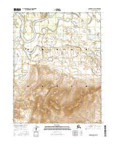
2016 Map of Shungnak D-3 SE
USGS Topo · Published 2016About this map
The Kobuk River meanders through the northern section of this quadrangle, forming complex oxbows and backwaters in the Northwest Arctic region. This landscape is defined by the shifting course of the water, where the Pick River flows southward into a terrain punctuated by numerous small ponds and marshlands. To the southwest, Tekeaksakrak Lake sits at the base of rising elevations, marking the transition from the river valley to the southern hills. The intricate contour lines in the lower half of the sheet illustrate a significant change in topography, moving away from the fluvial plains into more defined ridges and drainages. The absence of roads or permanent settlements in this 2016 survey emphasizes the wilderness character of the area, where the Public Land Survey System grids such as t17n r8e and t16n r8e provide the only human-imposed structure on the natural drainage patterns.
Find a feature on this map
7 named features on this map. Tap any name to fly to it.
Don’t see what you’re looking for? This feature index may not catch every label — zoom into the map to look around manually.
Map Details
Editions of this 2016 Shungnak D-3 SE Map
This is the sole edition of this map. No revisions or reprints were ever made.
Other maps of this area

1951 · Shungnak
USGS Topo · 1:250,000

1955 · Shungnak
USGS Topo · 1:250,000

1955 · Shungnak D-2
USGS Topo · 1:63,360

1955 · Shungnak D-3
USGS Topo · 1:63,360

1964 · Shungnak
USGS Topo · 1:250,000
1985 · Shungnak C-3
USGS Topo · 1:63,360
1985 · Shungnak C-2
USGS Topo · 1:63,360
2016 · Shungnak D-3 NW
USGS Topo · 1:25,000
2016 · Shungnak D-3 SW
USGS Topo · 1:25,000
2016 · Shungnak D-3 NE
USGS Topo · 1:25,000