
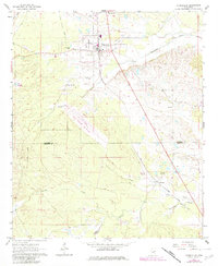
1962 Map of Shuqualak
USGS Topo · Published 1964About this map
Shuqualak anchors the northern portion of this 1962 landscape, situated where the Gulf Mobile and Ohio railroad intersects the state highway system. The town reflects a well-established community infrastructure, featuring the Shuqualak Sch and several large cemeteries including Shuqualak Cem and Martin Cem. To the south, the settlement of Wahalak is visible near the Noxubee and Kemper county line, illustrating the rural development patterns of East Mississippi during the mid-century.
Find a feature on this map
19 named features on this map. Tap any name to fly to it.
Don’t see what you’re looking for? This feature index may not catch every label — zoom into the map to look around manually.
Map Details
Editions of this 1962 Shuqualak Map
2 editions found
Other maps of this area

1953 · Meridian
USGS Topo · 1:250,000

1953 · West Point
USGS Topo · 1:250,000

1957 · Meridian
USGS Topo · 1:250,000

1958 · West Point
USGS Topo · 1:250,000

1963 · West Point
USGS Topo · 1:250,000

1963 · De Kalb
USGS Topo · 1:24,000

1963 · Townsend
USGS Topo · 1:24,000

1963 · Gholson
USGS Topo · 1:24,000

1965 · Meridian
USGS Topo · 1:250,000

1973 · Scooba
USGS Topo · 1:24,000