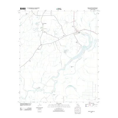
2012 Map of Sicily Island
USGS Topo · Published 2012About this map
Sicily Island rises above the alluvial landscape of Catahoula Parish, defined by a complex network of waterways including Black Bayou, Bayou Louis, and the winding Goose Bayou. This 2012 survey captures a rural landscape where industry and heritage overlap, featuring the Sicily Island Oil and Gas Field alongside numerous family and community burial grounds such as Old Pine Hill Cem and Pilgrim Cem. The settlement of Norris Springs sits to the north, while Leland serves as a western waypoint near the Leland Lookout Tower. Transportation and commerce are reflected in the presence of the Peck Landing Strip and a web of local routes like Bayou Louie Rock Rd. The map also illustrates the watery geography of Duck Creek Island and the expansive Lovelace Lake, providing a clear record of the region's hydrography and small-town infrastructure at the start of the 2010s.
Find a feature on this map
54 named features on this map. Tap any name to fly to it.
Don’t see what you’re looking for? This feature index may not catch every label — zoom into the map to look around manually.
Map Details
Editions of this 2012 Sicily Island Map
This is the sole edition of this map. No revisions or reprints were ever made.
Other maps of this area

1939 · Red Gum
USGS Topo · 1:62,500

1941 · Manifest
USGS Topo · 1:62,500

1941 · Sicily Island
USGS Topo · 1:62,500

1941 · Harrisonburg
USGS Topo · 1:62,500

1953 · Natchez
USGS Topo · 1:250,000

1956 · Natchez
USGS Topo · 1:250,000

1957 · Sicily Island
USGS Topo · 1:62,500

1959 · Natchez
USGS Topo · 1:250,000

1959 · Harrisonburg
USGS Topo · 1:62,500

1960 · Jonesville
USGS Topo · 1:62,500