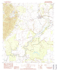
1983 Map of Sicily Island
USGS Topo · Published 1984About this map
Sicily Island rises as a distinct upland plateau above the complex wetland systems of the Mississippi River delta, as documented in this early 1980s provisional survey. The settlement patterns follow the higher ground and the Missouri Pacific rail line, with family and community life centered around several country churches and cemeteries, such as Pine Hill Ch and Norris Cem. The landscape is a intricate network of bayous and lakes, including the large Louis Island Creek (Lovelace Lake) and Black Bayou Lake. Numerous gravel pits and sand operations on the western slopes of the island suggest a local industry driven by the area's unique geological elevation, while the surrounding lowlands are marked by an extensive Oil Field and Gas and Field infrastructure near Little Black Lake.
Find a feature on this map
51 named features on this map. Tap any name to fly to it.
Don’t see what you’re looking for? This feature index may not catch every label — zoom into the map to look around manually.
Map Details
Editions of this 1983 Sicily Island Map
This is the sole edition of this map. No revisions or reprints were ever made.
Other maps of this area

1939 · Red Gum
USGS Topo · 1:62,500

1941 · Manifest
USGS Topo · 1:62,500

1941 · Sicily Island
USGS Topo · 1:62,500

1941 · Harrisonburg
USGS Topo · 1:62,500

1953 · Natchez
USGS Topo · 1:250,000

1956 · Natchez
USGS Topo · 1:250,000

1957 · Sicily Island
USGS Topo · 1:62,500

1959 · Natchez
USGS Topo · 1:250,000

1959 · Harrisonburg
USGS Topo · 1:62,500

1960 · Jonesville
USGS Topo · 1:62,500