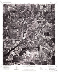
1976 Map of Sicily Island NW
USGS Topo · Published 1977About this map
Wisner sits at the northern edge of this 1976 orthophotoquad, serving as a primary point of reference in an area dominated by an intricate patchwork of agricultural fields. This aerial-derived survey from the State of Louisiana and the USGS provides a clear view of the rural landscape before modern development patterns fully took hold. The winding path of Deer Creek meanders through the central terrain, while the small settlement of Holly Grove appears further south. The map reflects the deep-rooted agrarian economy of the region, where the arrangement of fields and drainage patterns defines the land use and movement of the local population during the mid-1970s.
Find a feature on this map
3 named features on this map. Tap any name to fly to it.
Don’t see what you’re looking for? This feature index may not catch every label — zoom into the map to look around manually.
Map Details
Editions of this 1976 Sicily Island NW Map
This is the sole edition of this map. No revisions or reprints were ever made.
Other maps of this area

1935 · Winnsboro
USGS Topo · 1:62,500

1939 · Fort Necessity
USGS Topo · 1:62,500

1941 · Sicily Island
USGS Topo · 1:62,500

1941 · Harrisonburg
USGS Topo · 1:62,500

1953 · Natchez
USGS Topo · 1:250,000

1955 · Jackson
USGS Topo · 1:250,000

1956 · Natchez
USGS Topo · 1:250,000

1957 · Sicily Island
USGS Topo · 1:62,500

1958 · Winnsboro
USGS Topo · 1:62,500

1958 · Fort Necessity
USGS Topo · 1:62,500