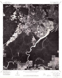
1976 Map of Sicily Island SW
USGS Topo · Published 1977About this map
Sicily Island sits at the heart of this mid-1970s orthophotoquad, where the transition between elevated agricultural lands and the low-lying wetlands of Catahoula Parish is captured through aerial photography. The settlement's grid is clearly visible, providing a direct view of the town's footprint as it existed in 1976. This specific perspective highlights how the local road network and residential areas were built to follow the contours of the higher ground, avoiding the dense forest and drainage patterns surrounding Lake Louis. The orthophoto format offers researchers a photographic record of land use and vegetation density, contrasting the cleared agricultural fields of the upland with the winding, wooded course of the lake and its associated bayous.
Find a feature on this map
2 named features on this map. Tap any name to fly to it.
Don’t see what you’re looking for? This feature index may not catch every label — zoom into the map to look around manually.
Map Details
Editions of this 1976 Sicily Island SW Map
This is the sole edition of this map. No revisions or reprints were ever made.
Other maps of this area

1939 · Red Gum
USGS Topo · 1:62,500

1941 · Manifest
USGS Topo · 1:62,500

1941 · Sicily Island
USGS Topo · 1:62,500

1941 · Harrisonburg
USGS Topo · 1:62,500

1953 · Natchez
USGS Topo · 1:250,000

1956 · Natchez
USGS Topo · 1:250,000

1957 · Sicily Island
USGS Topo · 1:62,500

1959 · Natchez
USGS Topo · 1:250,000

1959 · Harrisonburg
USGS Topo · 1:62,500

1960 · Jonesville
USGS Topo · 1:62,500