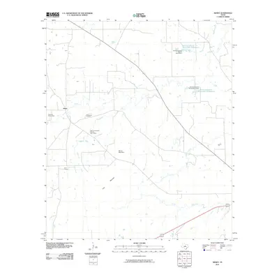
2010 Map of Sidney
USGS Topo · Published 2010About this map
Sidney sits at the heart of this landscape, where the local water management system of the Soil Conservation Service is a defining modern characteristic. The region is marked by a series of engineered reservoirs and dams, including the David M Pinson Dam and multiple Soil Conservation Service sites, which regulate the flow of Jimmys Creek and Sweetwater Creek. This drainage network suggests a reliance on carefully managed water resources for the area's agricultural or ranching operations.
Find a feature on this map
16 named features on this map. Tap any name to fly to it.
Don’t see what you’re looking for? This feature index may not catch every label — zoom into the map to look around manually.
Map Details
Editions of this 2010 Sidney Map
This is the sole edition of this map. No revisions or reprints were ever made.
Other maps of this area

1889 · Brownwood
USGS Topo · 1:125,000

1894 · Eastland
USGS Topo · 1:125,000

1894 · Brownwood
USGS Topo · 1:125,000

1954 · Brownwood
USGS Topo · 1:250,000

1954 · Abilene
USGS Topo · 1:250,000

1958 · Abilene
USGS Topo · 1:250,000

1966 · Star Mountain
USGS Topo · 1:24,000

1966 · Sipe Springs
USGS Topo · 1:24,000
1966 · Blanket
USGS Topo · 1:24,000
1969 · Duster
USGS Topo · 1:24,000