1981 Map of Sidney
USGS Topo · Published 1981About this map
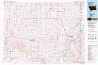
Sidney and the fertile river valleys of northeastern Montana appear in this 1981 compilation, which captures the region at a time of established agricultural and transit networks. The landscape is defined by the confluence of the Yellowstone River and Missouri River near the North Dakota border, where the Burlington Northern railroad serves as a critical transport artery for grain and freight. From the river bottoms to the higher plains of Butler Table, the map documents a network of small rail settlements and rural communities like Lambert and Enid.
Find a feature on this map
66 named features on this map. Tap any name to fly to it.
Don’t see what you’re looking for? This feature index may not catch every label — zoom into the map to look around manually.
Map Details
Editions of this 1981 Sidney Map
This is the sole edition of this map. No revisions or reprints were ever made.
Other maps of this area

1909 · Glendive
USGS Topo · 1:250,000

1912 · Poplar
USGS Topo · 1:62,500

1914 · Brockton
USGS Topo · 1:62,500

1953 · Williston
USGS Topo · 1:250,000

1953 · Watford City
USGS Topo · 1:250,000

1954 · Glendive
USGS Topo · 1:250,000

1954 · Wolf Point
USGS Topo · 1:250,000

1957 · Glendive
USGS Topo · 1:250,000

1957 · Williston
USGS Topo · 1:250,000

1957 · Watford City
USGS Topo · 1:250,000