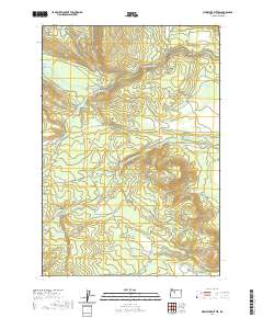
2020 Map of Sidwalter Buttes
USGS Topo · Published 2020About this map
The Sidwalter Buttes dominate the high desert terrain of Wasco County in this 2020 study, rising above a landscape defined by significant hydrological features. The Warm Springs River and its S Fork carve through the northern and central sections, supported by reliable water sources such as Warm Springs Meadows, Big Spring, and Nellie Spring. The naming of the local infrastructure, including Mount Wilson Schoolie Rd and Old Mill Schoolie Rd, suggests the historical importance of the Schoolie Pasture for ranching or community transit in this part of Oregon.
Find a feature on this map
58 named features on this map. Tap any name to fly to it.
Don’t see what you’re looking for? This feature index may not catch every label — zoom into the map to look around manually.
Map Details
Editions of this 2020 Sidwalter Buttes Map
This is the sole edition of this map. No revisions or reprints were ever made.
Other maps of this area

1924 · Mount Hood
USGS Topo · 1:125,000

1927 · Mount Hood
USGS Topo · 1:125,000

1927 · Mt. Jefferson
USGS Topo · 1:125,000

1928 · Madras
USGS Topo · 1:125,000

1930 · Mt. Jefferson
USGS Topo · 1:125,000

1930 · Dufur
USGS Topo · 1:125,000

1931 · Madras
USGS Topo · 1:125,000

1934 · Dufur
USGS Topo · 1:125,000

1953 · The Dalles
USGS Topo · 1:250,000

1955 · Bend
USGS Topo · 1:250,000