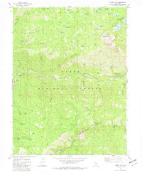
1981 Map of Sierra City
USGS Topo · Published 1982About this map
Gold mining history dominates this 1981 survey of the North Fork Yuba River canyon, where the steep terrain is marked by dozens of lode and placer operations. The community of Sierra City and the nearby settlement of Loganville serve as the primary hubs along the river, surrounded by legacy sites like the Sierra Buttes Mine and Young America Mine. Evidence of early alpine transport and ranching is seen at Butcher Ranch Meadow and Robinson Cow Camp, while the Henness Pass Road traces a historic immigrant and supply route through the southern portion of the quadrangle.
Find a feature on this map
73 named features on this map. Tap any name to fly to it.
Don’t see what you’re looking for? This feature index may not catch every label — zoom into the map to look around manually.
Map Details
Editions of this 1981 Sierra City Map
2 editions found
Other maps of this area

1891 · Downieville
USGS Topo · 1:125,000

1891 · Colfax
USGS Topo · 1:125,000

1892 · Colfax
USGS Topo · 1:125,000

1893 · Downieville
USGS Topo · 1:125,000

1894 · Colfax
USGS Topo · 1:125,000

1895 · Downieville
USGS Topo · 1:125,000

1896 · Downieville
USGS Topo · 1:125,000

1897 · Downieville
USGS Topo · 1:125,000

1898 · Colfax
USGS Topo · 1:125,000

1900 · Colfax
USGS Topo · 1:125,000