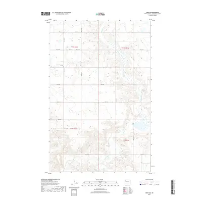
2017 Map of Sikes Dam
USGS Topo · Published 2017About this map
The Little Knife River meanders through the Missouri Plateau of Mountrail County, carving a distinct valley across this northern landscape. This 2017 survey captures a rural territory defined by section-line roads and the occasional spiritual landmark. Notable community sites include the Scandia Valley Lutheran church and the adjacent Free Cem, which serve as focal points for local history and genealogy. The terrain is further shaped by Sikes Dam, creating a reservoir along the river's path. A network of local roads, such as 56th St NW and 87th Ave NW, provides the framework for the agricultural operations that dominate this portion of North Dakota.
Find a feature on this map
17 named features on this map. Tap any name to fly to it.
Don’t see what you’re looking for? This feature index may not catch every label — zoom into the map to look around manually.
Map Details
Editions of this 2017 Sikes Dam Map
This is the sole edition of this map. No revisions or reprints were ever made.
Other maps of this area

1953 · Williston
USGS Topo · 1:250,000

1957 · Williston
USGS Topo · 1:250,000

1969 · Stanley
USGS Topo · 1:24,000

1969 · Stanley SE
USGS Topo · 1:24,000

1981 · Belden SW
USGS Topo · 1:24,000

1981 · Robinson Lake
USGS Topo · 1:24,000
1981 · Rat Lake SE
USGS Topo · 1:24,000
1981 · Belden SE
USGS Topo · 1:24,000

1981 · Ross
USGS Topo · 1:24,000

1981 · Stanley SE
USGS Topo · 1:24,000