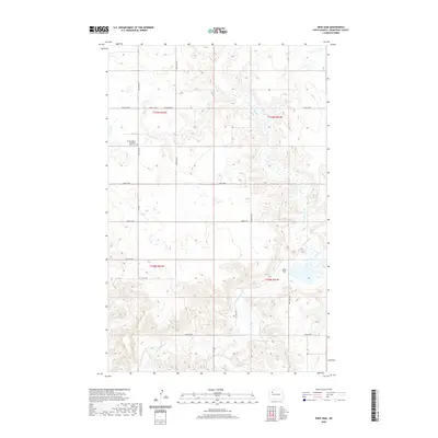
2020 Map of Sikes Dam
USGS Topo · Published 2020About this map
Little Knife River meanders through this section of Mountrail County, carving a valley across the plains north of Sikes Dam. The landscape is defined by the Public Land Survey System grid, with township boundaries like t155n r92w and t154n r91w organizing the rural sections. A network of gravel and section-line roads, including 86th Ave NW and 54th St NW, provides access to the high ground above the river breaks. On the western edge of the quadrangle, the Scandia Valley Lutheran Free Cem serves as a significant genealogical marker for the early Scandinavian settlers of this prairie region. The U.S. Geological Survey maintains this record of the water levels and rural infrastructure, documenting the sparse but deliberate human footprint on the North Dakota landscape.
Find a feature on this map
22 named features on this map. Tap any name to fly to it.
Don’t see what you’re looking for? This feature index may not catch every label — zoom into the map to look around manually.
Map Details
Editions of this 2020 Sikes Dam Map
This is the sole edition of this map. No revisions or reprints were ever made.
Other maps of this area

1953 · Williston
USGS Topo · 1:250,000

1957 · Williston
USGS Topo · 1:250,000

1969 · Stanley
USGS Topo · 1:24,000

1969 · Stanley SE
USGS Topo · 1:24,000

1981 · Belden SW
USGS Topo · 1:24,000

1981 · Robinson Lake
USGS Topo · 1:24,000
1981 · Rat Lake SE
USGS Topo · 1:24,000
1981 · Belden SE
USGS Topo · 1:24,000

1981 · Ross
USGS Topo · 1:24,000

1981 · Stanley SE
USGS Topo · 1:24,000